What Is ENSO and Why Does It Matter?
El Niño and La Niña are the two opposing phases of a natural climate pattern called the El Niño-Southern Oscillation, or ENSO. This cycle is one of the most powerful drivers of year-to-year climate variability on Earth, capable of shifting rainfall, drought, and temperature patterns across entire continents - sometimes simultaneously.
The name El Niño was coined by Peruvian fishermen who noticed unusually warm waters arriving off their coast around Christmastime, calling it "El Niño" (Spanish for "the boy child," evoking the Christ child). La Niña - "the girl child" - is the cooler, opposite phase. Between the two extremes lies a neutral state where conditions are neither unusually warm nor unusually cool.
ENSO
El Niño-Southern Oscillation - the recurring cycle of warming and cooling in the tropical Pacific Ocean that drives large-scale shifts in global weather patterns.
Trade winds
Steady, easterly winds that blow across the tropical Pacific from east to west near the equator, playing a central role in controlling ocean surface temperatures.
Upwelling
The process by which deeper, colder ocean water rises to the surface, typically along coastlines where surface water is pushed away by winds.
Sea surface temperature anomaly
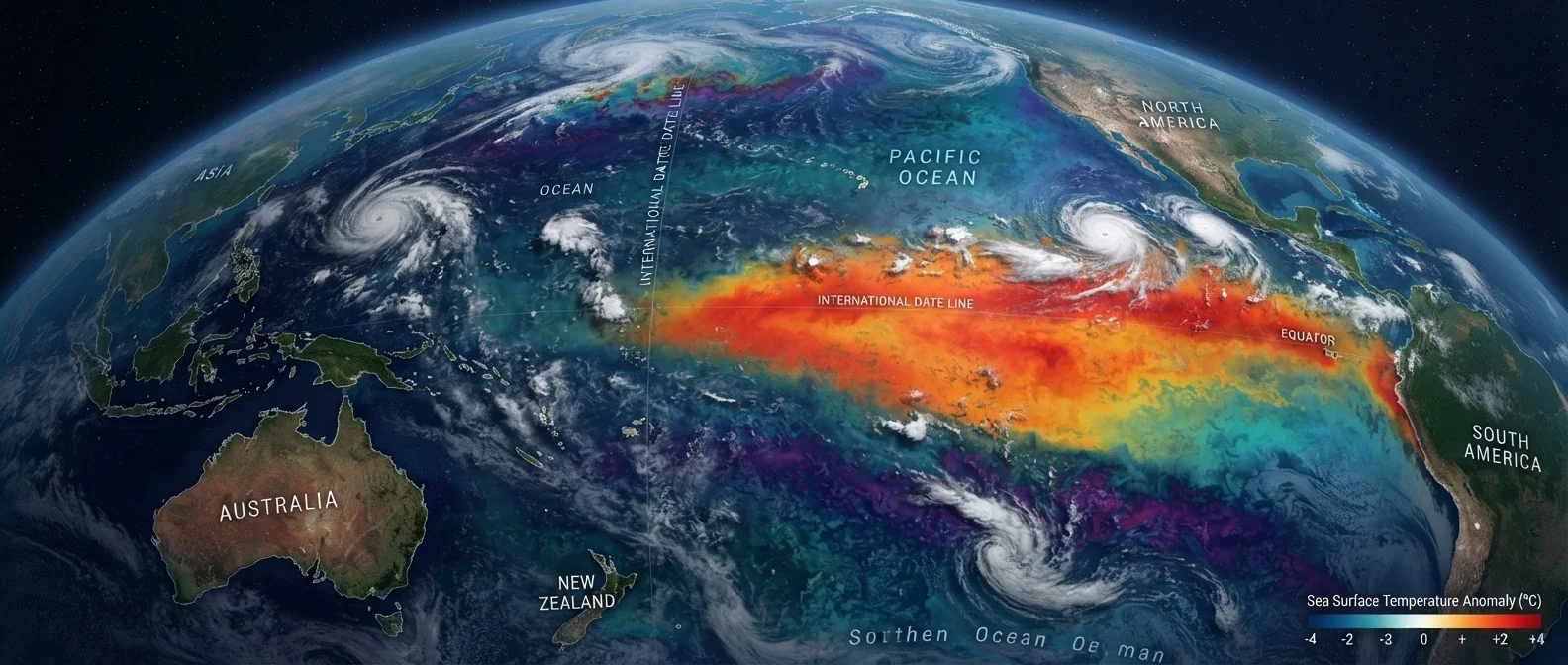
The difference between the observed ocean surface temperature and the long-term average for that location and time of year - a key measure for detecting ENSO events.
Jet stream
A fast-moving band of air high in the atmosphere that steers weather systems; ENSO events can shift its position, altering storm tracks across North America.
Understanding ENSO matters far beyond meteorology. Its effects ripple through agriculture, water supplies, wildfire risk, and public health. Knowing whether an El Niño or La Niña is developing can help communities, farmers, and emergency managers prepare months in advance.
The Ocean-Atmosphere Engine Behind El Niño
The tropical Pacific Ocean is the stage for ENSO, and the interaction between ocean water and overlying atmosphere is the central mechanism. Under normal conditions, trade winds blow westward across the equatorial Pacific, pushing warm surface water toward Australia and Indonesia. This allows cooler, nutrient-rich water to rise along the South American coast - a process called upwelling.
During El Niño, those trade winds weaken. Warm water that had been piled up in the western Pacific sloshes eastward toward South America. Sea surface temperatures in the central and eastern Pacific rise significantly above average - the defining signature of an El Niño event. That pool of warmer water changes where the atmosphere convects most vigorously, shifting rainfall patterns and altering the jet stream far from the tropics.
To understand how the ocean and atmosphere work together as a coupled system, see our guide to ocean currents and climate, which explains how heat moves through the ocean to shape weather worldwide.
La Niña: The Cold Counterpart
La Niña is not simply the absence of El Niño - it is an active, intensified state. During a La Niña event, trade winds strengthen beyond their normal intensity, driving even more warm water westward. Upwelling along the South American coast amplifies, and sea surface temperatures in the central and eastern Pacific drop below average.
The atmospheric response is a near mirror image of El Niño. Convection shifts strongly toward the western Pacific and Indonesia, bringing above-average rainfall to that region. Meanwhile, the altered jet stream produces its own suite of climate anomalies across distant land areas.
How to Find Current ENSO Forecasts
NOAA's Climate Prediction Center publishes free, regularly updated ENSO outlooks at climate.gov. These forecasts show the probability of El Niño, La Niña, or neutral conditions for the coming months - useful for anyone planning around seasonal weather variability. Looking at the Oceanic Niño Index chart is a good starting point for seeing where the current cycle stands historically.
La Niña events are sometimes overlooked because they produce less dramatic ocean warming than El Niño - but their impacts on drought, flooding, and storm tracks can be equally significant, and in some regions, more severe.
How Scientists Detect and Track These Events
Modern ENSO monitoring relies on a network of ocean-atmosphere observing systems. The Tropical Atmosphere Ocean (TAO) array - a grid of moored buoys stretching across the equatorial Pacific - continuously measures sea surface temperatures, wind speed, and ocean heat content at depth. Satellites independently track sea surface temperatures and sea level height, since warmer water expands slightly and creates a measurable rise detectable from space.
Forecasters use a key index called the Oceanic Niño Index (ONI), which tracks the three-month average sea surface temperature anomaly in a defined region of the central Pacific. An ONI of +0.5°C or above for five consecutive overlapping periods officially qualifies as an El Niño; −0.5°C or below qualifies as La Niña.
Climate models then assimilate this observational data to issue outlooks. NOAA's Climate Prediction Center publishes regular ENSO forecasts that governments, farmers, and disaster planners use to prepare for likely seasonal conditions months before they arrive.
Real-World Impacts Across the United States
No two ENSO events produce identical impacts, but well-documented patterns repeat often enough to be genuinely useful for planning. During El Niño winters, the southern tier of the United States - including California, the Gulf Coast, and the Southeast - typically sees wetter-than-average conditions. The Pacific Northwest and parts of the upper Midwest tend to run warmer and drier than normal.
La Niña winters tend to flip that script. The southern United States, particularly the Southwest and Texas, often sees drier conditions and elevated wildfire risk. The Pacific Northwest and Northern Rockies frequently experience colder, snowier winters. For the central and eastern United States, La Niña is often associated with more active tornado seasons during spring.
These are tendencies, not certainties. Local geography, the strength of the event, and interactions with other climate patterns all modulate what any given location actually experiences. But because ENSO signals emerge months before their peak impacts, they represent one of the most valuable seasonal forecasting tools available to science - a genuine window into what the Pacific's mood might mean for weather in your backyard.